Article is blow this top vid on Bully China Owns All Seas? Philippines defense chief outraged over South China Sea note
The Philippines defense secretary has hit out at China after a note over territorial claims in the South China Sea was passed to him during a speech in South Korea. Gilberto Teodoro accused Beijing of coercion, bullying and aggression. The Philippines and China have clashed repeatedly over the South China Sea. Beijing claims sovereignty over nearly the entire waterway despite a 2016 ruling by an international arbitration tribunal that found its claims had no legal basis. China does not recognize the ruling.
Bully China Owns All Seas?
1 — China drew a line through everybody else’s water. They think they own the oceans. Without the U.S. on the scene, the sad fact is they do. Their navy is now larger than America’s. They are ready to enter their conquest phase of Empire within the next two years. Which means, Taiwan is gone right after Trump leaves office. This happens faster, as in next year, if the Democrats steal Congress and the Senate in November, impeach Trump and Vance by next Feb or March and then install their Marxist Speaker of the House as POTUS.
Philippine defense chief called Beijing out on a Seoul stage. The map is the real story.
A Chinese military attaché handed Philippine Defense Secretary Gilberto Teodoro Jr. a note while he was mid-answer at the Seoul Defense Dialogue on September 8. The note restated Beijing’s position that the 2016 South China Sea arbitration is “illegal, null and void” and has “no binding force.” Teodoro did not pocket it. He read it aloud, line by line, and answered each line in front of the host country and a room of defense ministers.
“So what you signed — UNCLOS — you mean violates international law.”
“No binding force? Because you don’t want to be subjected to UNCLOS.”
On China refusing the award: “Of course, because you lost.”
Then, in Filipino: Mahiya naman kayo. Have some shame. He called the stunt “actual coercion, bullying and aggression,” not gray-zone pressure, and said he would keep the paper as “a memento of how desperate China is.” The hall applauded. The Philippine Department of National Defense posted the video. It ripped across X.
Beijing’s answer was the usual one. Foreign Ministry spokeswoman Mao Ning told Manila to “stop this grandstanding and lying” and to “protect China-Philippine relations and the peace and stability of the South China Sea.” Peace, in that vocabulary, means the other country sits down and accepts the map.
The map is the policy.
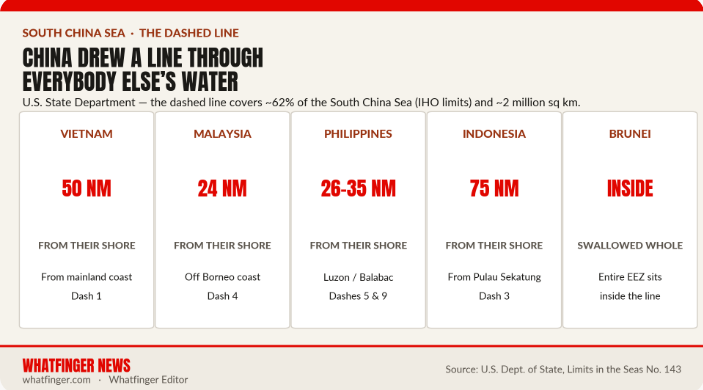
China’s dashed line — nine dashes on the 2009 UN note, ten on the 2023 “standard map” — is drawn so close to other countries’ coasts that it is not a claim in the South China Sea. It is a claim over the South China Sea. The U.S. State Department measured it at about 2 million square kilometers, roughly 62 percent of the sea under International Hydrographic Organization limits. Popular shorthand still says 80 to 90 percent. Either number is a land grab by sea.
Look at the distances, not the slogans.
Dash 1 sits about 50 nautical miles off Vietnam’s mainland. Dash 4 sits 24 nautical miles off Malaysian Borneo. Dash 5 sits 35 nautical miles off the Philippines’ Balabac. Dash 9 sits about 26 nautical miles from the Philippines in the Luzon Strait. Dash 3 sits about 75 nautical miles from Indonesia’s Pulau Sekatung. Brunei’s entire exclusive economic zone sits inside the U. The 2023 standard map adds a tenth dash east of Taiwan — close enough to crowd Japan’s Yonaguni. That is not “adjacent waters.” That is a line drawn through other nations’ kitchens.
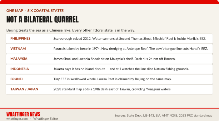
China did not invent this quarrel with the Philippines alone. Vietnam lost the Paracels to Chinese force in 1974 and still watches new dredging in those islands. Malaysia’s James Shoal and Luconia Shoals sit on Malaysia’s own continental shelf and still get Chinese patrols. Indonesia insists it has no island dispute with Beijing and still watches Chinese vessels work the Natuna grounds. Taiwan holds the same old Republican-era dashed map China later inherited — and now lives with a tenth dash off its east coast. The 2016 case was filed by Manila. The line it shredded runs through half of ASEAN.
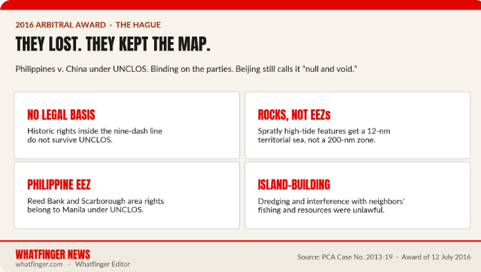
The Hague tribunal was not vague. Historic rights inside the nine-dash line have no legal basis under the United Nations Convention on the Law of the Sea — a treaty China signed. High-tide rocks in the Spratlys get a 12-nautical-mile territorial sea, not a 200-mile exclusive zone. Reed Bank sits in the Philippine EEZ. China’s interference with fishing and resources, and its island-building on low-tide features, was unlawful. China boycotted the hearings, lost, and declared the award a scrap of paper. Ten years later it is still the scrap of paper Beijing tries to pass across a conference table in Seoul.
A Chinese official attempted some of that Wolf Warrior Diplomacy ™ shit. It did not go well.
This guy responding is our kindred spirit.
Philippines’ Defence Minister Gilberto Teodoro was speaking up for smaller nations and international law at a forum in Korea when a staff…
— Bad Baltic (@BadBalticTakes) September 8, 2026
What “bullying” looks like at sea is not a metaphor. Chinese coast guard and maritime militia swamp Scarborough Shoal, which Beijing seized in 2012. Water cannons hit Philippine resupply boats at Second Thomas Shoal, where a rusting landing ship is Manila’s outpost on its own continental shelf. Mischief Reef — a Chinese airfield and base — sits inside the Philippine EEZ, a few hundred kilometers off Palawan. Vietnam is watching new sand pumped onto reefs in the Paracels. Survey ships trace the outer edge of the dashed line as if it were a border. Cameras keep recording it. That is why X fills with the same clips: one wooden boat, a wall of white hulls.
The money under the map is why Beijing will not drop it. The sea carries on the order of $5 trillion in trade a year. Under the seabed sit oil and gas estimates in the billions of barrels and hundreds of trillions of cubic feet. Fish stocks feed coastal cities from Luzon to the Mekong. A dashed line that swallows other countries’ EEZs is a claim on fish, fuel, and the shipping lanes that feed East Asia. Call it “historic rights” if you want. The operational version is coast-guard ramming, militia swarms, and a diplomat’s note slid onto a minister’s table while he is speaking.
ASEAN has never produced a binding code of conduct that actually stops this. Some members trade too much with China to say the quiet part. The Philippines took the legal route and won. Vietnam delimits EEZs with Indonesia and leaves Beijing out of the room. Japan and the Philippines talk boundaries east of Taiwan — and China objects because it treats those waters as an extension of the same claim. The pattern is consistent: neighbors try to use the law of the sea. Beijing uses presence, maps, and notes.
Teodoro’s line in Seoul was the part Beijing cannot spin. If your legal position were strong, you would not need an attaché to interrupt a panel in a third country. You would argue it in court. China already had that chance. It lost. It kept the map anyway, then added a dash.
This is one government drawing a line through the territorial seas and exclusive economic zones of the countries that actually live on that water — and daring them to do something about it in public. Only Trump and America stand in their way.
—The Whatfinger News Team: Sgt Pat and Sgt K
Resources
- Bully China Owns All Seas? Philippines defense chief outraged over South China Sea note
- Philippine defence chief slams ‘bullying’ China after note at forum — CNA
- ‘Have some shame’: How a note from China got Philippine defence chief Teodoro riled up — ThePrint
- (LEAD) Philippine defense chief slams China over audience note — Yonhap
- Teodoro rebuts China’s note onstage in Seoul: ‘Of course, because you lost’ — Philstar
- Beijing tells Manila to ‘stop lying’ after minister exposes South China Sea note — SCMP
- DND Philippines video: Teodoro reads the Chinese note — @dndphl
- PCA Case No. 2013-19, Award of 12 July 2016
- Nations reaffirm ruling invalidating China’s claims in South China Sea — AP
- U.S. Department of State, Limits in the Seas No. 143: China’s Maritime Claims in the SCS
- China Primer: South China Sea Disputes — Congressional Research Service
- Territorial Disputes in the South China Sea — CFR Global Conflict Tracker
- EIA: South China Sea analysis — claimants and resources
- Nine-dash line — Wikipedia overview of protests and overlaps
- China’s new ‘10-dash line’ map incorporates Taiwan, most of West PH Sea — Inquirer
- How China Is Normalizing Its Presence in the Waters East of Taiwan — The Diplomat
- Beijing’s Next Play for the South China Sea — Foreign Affairs
- Grab what you can while you can: The new reality in the South China Sea — BBC
- Why China’s Nine-Dash Line Is Problematic — LegalClarity
- Nine-Dash Line Map: Legal Status and Sea Disputes — LegalClarity
Top Features and Vids across all Whatfinger sites right now
- Man JUMPS to Safety as Truck Drives Off Cliff (this was close – 1 second away from death)
- Humor: Will this be Steve Inman’s best post with clips this week? See links under the market
- Democrat fraudsters stole MILLIONS of Medicare accounts’ Dr. Oz: This is RAMPANT FRAUD
- Matt Walsh TORCHES Feminism As The MOST Destructive Ideology In Human History
- Trump honors 9/11 heroes at Steel Across America memorial
- All the major AI tools say it’s not okay to hate Mohammed but it’s okay to hate Jesus